Thursday, October 27, 2011

Trail Review: High Creek Canyon to Naomi and Cherry Peaks

Distance:  19.0 miles
Vertical:  5900'
Difficulty:  Hard

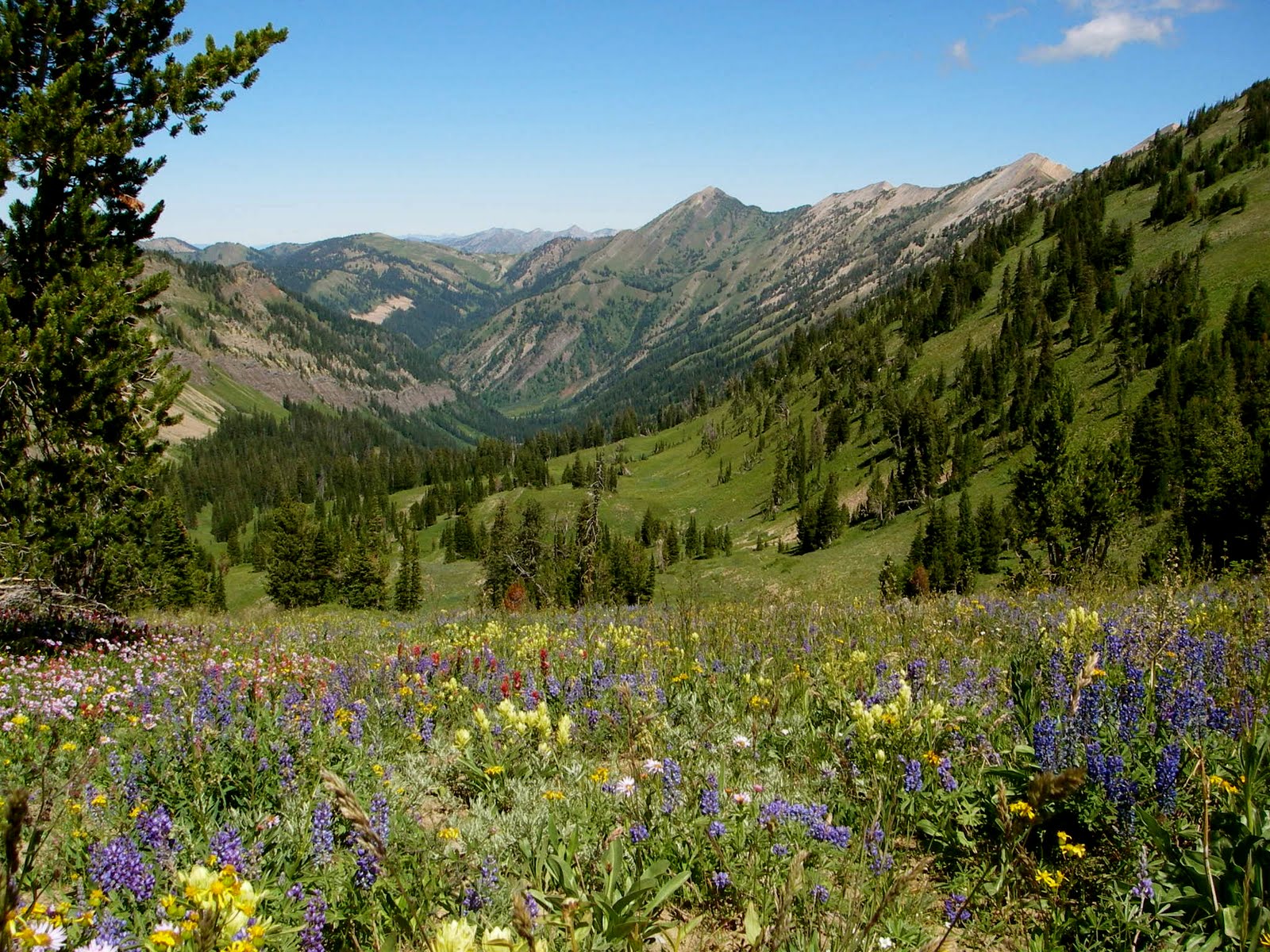
Looking North down High Creek Canyon from Cherry Peak

When Cody and I first attempted this trail, we made a couple of critical errors which resulted in more of an adventure than we bargained for.  First, we didn't get a map, second, we started at 4 AM with hours of darkness still ahead of us, and then, to top it off, we trusted that there would be a sign pointing in the correct direction.  Wrong.  Needless to say, we got quite lost, ended up bushwhacking up the wrong drainage for miles, and by the time we found the turn we missed, it was light enough to see that the sign had been ripped from the post.  Later that week, Cody went solo and scouted the trail and we were finally able to run it together last weekend, as what will likely be our last real high country trail run until the snows melt next spring. 

We started at a campground partway up High Creek Canyon, just East of Richmond, UT (north of Logan about 25 minutes), but you can start at the beginning of the dirt road to get in a few extra miles.  The road winds through a few campsites here and there for a mile or two, then ends in a parking lot.  This is where the single track starts.  It starts out flat for a few hundred meters, then takes a hard left across a foot bridge and begins to climb.  You alternate flat and climbing for a little while, until you reach a sign (or, if you're not lucky, a post).  DO NOT GO LEFT HERE!!!  Well, you can, and it will take you to a cool little waterfall, but that's as far as it goes.  There is nothing but misleading deer tracks after that point.  Go right at the sign across a rickety foot bridge (there are a few of these), and the trail begins to climb in earnest.  We did this trail in the late fall, and the colors mixed with the dark green fir was beautiful.  In the summer, it is very green.  You'll make a couple of switchbacks, and the trail will turn somewhat rocky as you continue to climb High Creek Canyon.  There is a nice little creek running by the trail, and you'll cross it several times.  There are always little bridges to cross, as the trail is also heavily used by horses.  Between mile 5 and 6 you'll come out of the forest upon a small pond.  Watch for moose here, as we know of at least two moose sightings at the pond.  You'll then cross a large meadow, where you'll have a great view of Cherry Peak directly in front of you.  Once you cross the meadow, the trail climbs steeply to the left, up the side of a very large bowl rimmed by cliffs.  The trail climbs a couple of steep ridges, and then drops down into High Creek Lake.  The freezing water is mirror smooth and clear enough to see to the bottom of the lake.  Looking to the South, you'll see a saddle above you.  The trail climbs to this saddle and splits at the top.  To the right is the way to Cherry Peak.  To the left, the trail to Naomi Peak.  We took Naomi to start with.  Naomi Peak is the highest point in the Bear River Range, and coming from this side is much more impressive than it is from the Tony Grove side, which is the short hike most people take.  The trail climbs about 1000' within a little over a mile to the peak.  You'll reach another saddle and another fork in the trail 4/5 of the way there.  Right takes you the last few hundred meters to the peak and left takes you down the hiking trail to Tony Grove.  Cody and I are planning to take this route next summer, traversing the way we came, to Naomi Peak, across the Seven Sisters and Mount Elmer, to Green Canyon, about a 50k run.  That will be an epic trail run.  This time, we paused for a few minutes at the peak before deciding that it was too cold and windy (there was about a foot of snow on the ground above 8,000' on this day) and turning around.  Follow the trail back the way you came to the saddle above High Creek Lake, and this time take the other fork.  You'll be able to see the trail ahead of you as it skirts another large bowl, slanting steeply up the side of Cherry Peak.  You'll reach yet another saddle, and from here the trail kind of disappears, leaving you to find your own best route to the summit.  This peak offers breathtaking views of High Creek Canyon, City Creek Canyon, Cache Valley, Naomi Peak, the Seven Sisters, and all the other peaks to the South.  We paused here to drink some water, snap some pictures, and eat some of Cody's granola bars before heading back down the way we came.  Going down High Creek Canyon is somewhat technical, with all the rocks, but is not nearly as bad as it looks coming up.  Enjoy the downhill and the views as you make your way back to the start point.  


Here are some photos:

View of Cherry Peak coming up High Creek Canyon


Yours truly at High Creek Lake


High Creek Lake from the saddle


The last bit of the high saddle near Naomi Peak


Looking SE near Naomi Peak


Possibly the most hardcore photo of me in history, from the top of Cherry Peak


Looking back towards Naomi Peak (top center) over what we just ran across

Accessibility:  About 25 minutes drive from Logan.  2 Stars

Runnability:  Rocky in places, but not as bad as it looks.  3 Stars

Scenic Value:  Two peaks at or above 10K, great views of the valley and surrounding mountains.  5 Stars

Overall Rating:  3.3 out of 5 Stars.  Great for a long, tough, weekend run with lots of vertical, spectacular views, and everything that makes trail running great.

Wednesday, October 12, 2011

As I wax philosophical...

I usually avoid non-running related topics on this blog, especially politics, but in light of current events, I felt the need to produce and share the following.  While it's obvious that some things need change (they always do), lets remember the big picture.

Saturday, October 1, 2011

Race Report: St. George Marathon

First of all, apologies to the few faithful followers of my blog for my lack of posting.  School and other pursuits have largely commandeered my time, leaving little for blogging.  But, I think I should be able to fit in some time here and there, now that things have settled down to a semi-predictable schedule. 

Distance:  26.2 miles
Time:  2:43:40
Place:  29 (2nd in age division)

This story begins yesterday afternoon.  I left Logan at a little after 1 PM, knowing that there would be significant traffic issues in Provo due to the construction combined with the USU/BYU football game, therefore I planned to take an alternate route leaving the freeway in Riverton, and taking Redwood Road around the west side of Utah Lake to avoid the delays.  This plan would have worked nicely, except everyone else apparently had the same idea.  As a result, I was delayed over an hour from what I was planning, and got quite behind.  I barely made it to St. George in time to pick up my packet, and was in a very stormy mood from the frustration of the trip.  After running a couple of necessary errands I was finally able to get home to my parents' house in Hurricane.  I was not able to get to bed until 11:00 PM, and didn't sleep too well. 

I woke up at 4:00 AM, got my stuff together and soon headed out for the bus loading zone at the finish line in St. George.  I got there in plenty of time and after a short wait was able to board a bus and got to the starting line with about 45 minutes to spare before the start.  Perfect.  I earned a quick star before the lines got long, and sat and chatted with the other SGRC/FRB guys.  It was good to see guys like Dave Holt, LoganFielding, Steve Hooper (owner of SGRC), Wildbull, and everyone else.  About 20 minutes before the start I made another pit stop to release the river and then got ready to start.  The wheelchairs went first, and then we were on hour way within just a few minutes.  In the first mile I found Dave, Clyde, Benjamin (?), Jeff Shadley (another FRBer I had just met in person for the first time), and a few others I didn't know so well.  We formed a close pack and settled down at a great pace for sub-2:30.  I had not run in a pack like this since high school track, and I must say it was really nice to have those guys to chat with and to help push me.  It was nice to catch up with Dave, as he had been a big part of my high school career.  The first few miles were uneventful, and we took a relaxed, but fast pace.  I had been worried coming into the race about my ability to run at that pace, but I was feeling great.  Veyo hill was much tougher than I remember, probably because I was running a minute per mile faster average in this race as in 2008, but we got through it in great shape.  At the top we discovered that there was a bit of a headwind, but we were able to conserve energy by taking turns drafting.  Again, I loved running with a solid pack, and we were all keeping together really well.  We came through the half at a very solid 1:15:30 (or maybe it was 1:16:30), on track to break 2:30 with ease.  At mile 14, the course drops into the abyss and our pace accordingly increased significantly.  At this point I was beginning to feel some fatigue, especially with my breathing, which I was not expecting.  I figured it was just the fast pace and didn't think much of it. 

But, as we began to climb the last significant rise coming out of Winchester Hills, it came back to bite me.  I began having trouble getting oxygen and was struggling to avoid hyperventilating.  My heart seemed to be skipping beats and I lost speed going up the hill and lost contact with the group.  One of Dave's former XC runners (he coaches at Pine View HS) was helping to pace us by this point, and he dropped back to try and rescue me, which I appreciated, but I was only able to surge for a few meters at a time and could not stay with him.  Very quickly I developed some bad stomach cramps and slowed to a near walk.  It was not pretty at all.  My legs began to tighten up, and I was reeling like a drunken sailor.  By the time I finally reached the top of the hill, the pack had quite a gap on me, and to make matters worse I could not get anything going.  At this point I knew there was little hope of recovery.  My legs were frozen, I felt sick every time I dipped under 7 minute pace, and I could barely get air into my lungs.  All I wanted to do was get to the next aid station (Mile 19) and bail out.  Somehow, when the aid station came up, I ran past it.  I only took water, as Gatorade sounded nauseating, and I took a second cup to dump on my head.  The next 6 miles followed the same pattern.  Just trying to put one foot in front of the other and at least finish this stupid thing.  2:30 was out the window long ago, and 2:40 was fading fast.  I still could not get anything going.  I felt embarrassed when people would cheer me on.  I was not looking strong, great, or feeling anything of the kind, though that's what people were telling me.  Steve, Logan, Jeff (who had dropped back long ago), Walter, and a couple of others passed me like a parked car.  Finally, I reached the 25 mile mark.  Walter was just ahead of me walking, and I determined to catch him and if nothing else at least try and help him along.  I picked up the pace and for the first time in the past 7-8 miles I didn't feel sick.  Walter followed me for a bit, but soon dropped back again, and I kept going just so I could get this nightmare over with.  I finally made it to the finish chute and have never been more glad to see the finish line ahead.  I crossed the line in 2:43:40, which was much better than what I was thinking I would get--a PR for the course actually (mostly because my first time was also my marathon debut and was not particularly impressive). 

To say I was disappointed in the result would be an understatement.  I was on pace for a huge PR under 2:30 at mile 18, but then everything fell apart so fast it made my head spin.  Whether it was the stress from the previous day, some problem with fueling (too much electrolytes?), lack of marathon specific training, or a combination thereof, the result was the same.  I just need to learn from it and move on, and appreciate what I was able to get out of it.  Instead of feeling sorry for myself I should feel grateful that I even have the ability to finish a marathon, let alone complain about a 2:43 finish time.  There will be other race days, and hopefully I will be able to correct any problems, train better, and have a better race next time. 

Saturday, August 13, 2011

Race Report: El Vaquero Loco 50k

Distance:  32 miles (8200' vertical)
Time:  6:02:43
Place:  2


Wow.  That is about all I have to say about this race.  If you call yourself an ultrarunner, you'd better do this one at least once.  Ty Draney puts on this race in the beautiful little town of Afton, WY.  Cody and Jon, my two training partners, talked me into signing up for this race, but then Jon wussed out and moved to South Carolina (something about some job with GE or something), and Cody has been out basically all year with an ITB injury, so I ended up going this one alone, as far as training buddies go.  Anyway, on to the report.  Ty reserved an entire campground for the participants and their families (courtesy of the Forest Service), so I got to stay there for free instead of having to pay for a motel room or paid camping.  The minute I pulled into Star Valley, I knew that this was going to be a memorable race because the scenery was just majestic.  I was not to be disappointed.  I went to bed around 9, and slept like a baby, as my old CC coach from high school let me use his air mattress.  I woke up once at about 3 AM because the moon was so bright that I thought that someone's headlights were on me and I had missed the start.  I didn't sleep much after that, but it was ok because I didn't feel tired.  I got out of bed at 4:25, 5 minutes before my alarm, and packed all my camping gear back into my car and got all my things for the race ready.  I did accidentally leave my Garmin sitting on my dash, but other than that I had everything.  I boarded the bus to the start line at about 5:10, and after a few minutes of lurching up a dirt canyon road we arrived.  The weather was clear, and quite chilly, so it was a lucky thing that Ty had included a hoodie in the packet instead of a shirt, because I didn't even think about bringing one, thinking the summer weather wouldn't be cold.  After a few minutes of warming up I was fine though.


The race started on time, and I joined up with the lead pack going at a very comfortable pace.  Luke Nelson had won this race the previous three years and held a very respectable course record, so I had no intention of going out with him, and he quickly dropped the three of us following.  We kept a loosely formed chase pack all the way to the turnaround of the first lap.  The group consisted of a guy named Ryan, Micah who had run with Jon and Cody last year, and myself.  The pace was pedestrian, but I knew that it was for a reason, as this course is very difficult in the later stages.  Due to snow problems, the course had been revamped to be a double out and back on the Swift Creek side of the course, and consequently clocked out at 32 miles and 8200 feet of vertical, instead of the usual 31 miles and 9,000 feet (this according to Luke's assessment, as I forgot my Garmin).  The trail climbed very gradually for the first 5.5 miles, with just a few steep sections before we got to the aid station.  Micah and I had plenty of stuff, and I had just taken my first gel,I so we blew through.  Ryan stopped, but quickly caught back up.  The next section is incredibly scenic, but is equally grueling.  I don't know the exact figures, but it climbs a LOT.  Even being fresh we found ourselves power hiking most of this section.  The second lap became an ominous prospect.   We finally got to the top of the first major ridge, and were able to look out over the mountains.  The view was stunning with the sun coming up over the mountains to the east.  Taking the trail to the right, we ascended a few more feet up to a saddle at about 10,000 feet.  From here, the trail took a big nose dive down to a small alpine lake.  There was a big snowfield here too, and on the second lap when the snow had softened, many people simply glissaded or simply slid down it. Once we ran around the lake, the trail quickly climbed up again, and we gained almost all the elevation we had lost.  We then took another, bigger nose dive down an incredibly steep slope to the second lake and the turnaround.  Here I grabbed a few pretzels and we were off again, heading back up the crazy slope we had just come down.  I could feel the fatigue in my quads, but before I knew it we had reached the top of the main saddle above the first lake again and were beginning the long descent back to the start line/turnaround.  At this point in the race, I could feel the fatigue setting in, but I was still feeling pretty spry.  I was glad, however, that Micah didn't try to set any land speed records heading back down.  We moved at a quick, but sustainable pace all the way back to the first canyon we had entered.  By now, I could really feel that my quads were slowly being shredded, as they began to complain at any change from downhill to uphill or vice versa.  But I was still feeling pretty good otherwise.


Ryan had long since dropped off, so it was just Micah and myself who arrived at the turnaround/aid station.  I was feeling pretty good, and Ty gave me a nice little pep talk while I was grabbing some Nuun and some more pretzels.  I was in and out in probably under 30 seconds, leaving Micah doing something with his drop bag.  I reasoned that if I wanted a chance to win or take second I would have to put the hammer down on this lap, so I moved into a faster, but still relaxed pace.  I was mentally comparing this race to running a mile back in HS track.  My coach would always tell me that the race was won or lost in the third lap, so this leg of my journey became my "third lap."  As I ascended up onto the single track, I could feel the burning in my quads.  It was going to be a long 16 miles until I could finish.  Surprisingly, however, I was able to maintain a good clip though.  I was running all but the steepest uphills and generally feeling great.  I had taken a few of my Shot Bloks during the final stretch of the first lap, and they were apparently kicking in.  I figured that my best chance at this point was to go hard as long as I could maintain it, and then just try to keep it respectable after that.  I was very pleased with my mental state in this race.  It's been a weak point for me for the last few weeks of training, but in this race I was really able to push hard even when the going was tough.  I made it most of the way to the aid station before that happened, but when it did, this race showed its teeth with a vengeance.  I did not bonk, but when the terrain became steep and rocky again my fatigue really began to show.  I had long since lost sight of Micah (as I found out later, he dropped out at the aid due to ITB issues), but I was still trying to spread the gap as much as I could, and also make up time on Luke.  I reached the aid in good enough shape, but very tired.  I filled up on water and took a Honey Stinger (too sweet, but they work wonders) and began the long hike to the saddle.  And it was a hike.  I was able to run a few seconds at a time here and there, but for all intents and purposes the entire section was at a fast hike.  My consolation was that everyone was doing the same, even the 25k guys.  It was nice to have them to pull me along, and they all offered words of encouragement which was very helpful.  Despite the slight trail congestion, it was really good to have them there, and they were all courteous and let me by.  It's always better to be around people when you are trying to gut out a hard climb like this.  After what seemed like an eternity of burning quads and calf muscles, I finally reached the top of the ridge.  From here I was able to run most of the slight uphill to the saddle.   The descent into the lake was slow and brutal on the quads, but I made it in one piece.  I passed Luke near the top, going the other way, and was able to take heart in the fact that I had made up 3-5 minutes on him, though that was probably as close as I got to him.  The climb to the second saddle was excruciating, but somehow I made it.  The second descent was similar.  At the aid station I paused to fill up on water and Nuun, and grabbed a few more pretzels.  The hike out was absolutely horrible.  I felt like I was barely moving.  I think it took me 10 minutes at least.  I had to quit looking down or up and just look at where my feet were going.  Somehow I made it to the top, only to drop down again into the first lake.  This climb was not quite so bad, but was still torture.  I had no idea how I was going to run the last miles downhill.  My quads were totally gone at this point.  I did make it to the top, though, and somehow I forced myself to begin running at this point.  And I just kept running.  I thought that if I stopped I might not be able to start again, so I willed myself forward, if for nothing else but to just get this over with.  I was passing all the runners at this point, some for the second or third time, and as before it was good to hear the encouragement.  It really kept me going.  I made it to the aid station again with no problem, filled up my water, and kept running.  I thought about taking more Shot Bloks, but the thought of eating made me feel like I would throw up if I did, so I didn't.  I had long since thrown my uneaten pretzels to the squirrels.  Hope they enjoyed it.  The task now was just to make it through the last 5 miles.  I had to walk a couple of small uphills which before I wouldn't have even thought about, a sign that my body was nearing the end of its rope.  I just hoped to finish before that happened.  After running through what seemed like endless meadows of wildflowers, I finally made it to the final stretch, running west down the canyon towards the start/finish line.  From somewhere I got the energy to really start to run hard again, though I was still forced to walk nearly all of the uphills.  Maybe I was just "smelling the barn," so to speak, but I was able to make surprisingly good time through this final section, though it seemed interminable at the time.  I was so tired.  I could barely think of anything besides just putting one foot in front of the other.  I wanted to walk the uphills, the downhills, and the level, but the thought of finally finishing kept me pressing onward at the best pace I could muster.  Eventually I could finally see the "lower trail" below me, and I knew I was almost home.  The final section was rocky, and I took it at a snails pace, but before long I could hear cheering and gave it one last push, taking the final turn into the finish.  I was done.


Finally.  After 6 hours, 2 minutes, and 43 seconds of running, I had finally completed the famed Vaquero Loco trail race.  My legs were shaking, and I could think of nothing but drinking some cold water and soaking in more of the same.  Even the burgers being prepared for everyone sounded awful at the moment (though they were quite tasty later on).  I received congratulations from Ty, Luke, and some of the other runners present, and just tried to sit and relax for a few minutes.  I had earned it.  I came into the race thinking I would be happy if I finished in the top 5, but I had taken second in a very tough race with some good competition.  At 32 miles, it was the longest distance I had ever run, and was also the longest time period I have spent running.  I was pleased with my effort, and pleased with the results.  The race was wonderful, and could not have been done better by Ty and all the volunteers.  The course was hands down the most scenic course I have ever run on.  It was everything an ultramarathon should be.  Tough, stunningly beautiful, remote, and long, but ultimately worth every step of the journey.  It's definitely on the docket for next year.

Trail Review: Bunchgrass-White Pine Trail

Distance:  14.6 miles
Vertical Climb/Descent:  3100'
Difficulty:  Hard


I had nearly forgotten this trail until I drove past the trailhead on the way to Stump Hollow the other day.  I've only done Bunchgrass/White Pine on two other occasions, but each time I am reminded that I should do it more often.  This trail is difficult, but gives you a good mix of just about every type of running you can think of.  You'll get your fill of steep climbing/descent, smooth and flat, meadows filled with sage and wildflowers, evergreen and aspen forest, rocks, stream crossings, sweeping mountain vistas, and the beautifully emerald White Pine Lake at the turnaround.  Oh, and cows...lots of cows.  Anyway, onward we go.  The trail begins right from US Hwy 89 about 0.25 miles past the turnoff to Tony Grove (about 30 minutes northeast of Logan).  Once you pass the Tony Grove turnoff, which is well signed, look for a big pullout on the right side of the highway.  This is your parking lot.  The trail starts just on the opposite side of the highway and is marked with one of those flat, brown posts they use to mark trails.  A few yards in, you'll come to a gate which you should go through.  The trail continues on the other side.  You'll climb fairly steadily for the first 2.5 miles, then you'll begin to ascend and descend a series of ridges, which will test your hill climbing abilities and footwork, but which will in return offer some great photo ops.  There are several junctions with other trails along the way, including a big one just past the 2.5 mile mark.  Bear left as a general rule (with one exception which I will mention later) and you will stay on course.  You'll traverse several meadows filled with fragrant wildflowers alternating with some thick stands of aspen.  During my last outing on this trail, I saw a big bull moose in this section (didn't get a good photo or it would be on here).  At the 3.8 mile mark, you'll come to a sign.  You want to keep left, as I stated before, heading towards White Pine Lake.  A right will take you to Franklin Basin, Steam Mill Hollow, and other points northeast (I plan on blogging a run including these trails at some point).  You are now on the Bear 100 course, in case you were wondering.  The trail soon enters a wide valley of alternating meadows and conifer forest.  Presently, you will see the imposing figure of Mount Gog (9700') straight ahead.  You're heading for a point about a quarter mile to the south of this prominent landmark.  At about 4.6 miles you will come upon a barely noticeable fork in the trail, right next to a small watering hole.  The trail appears to go up and to the left, but you should go down and to the right instead, near the stream.  You'll continue straight up the middle of this lush, steep sided valley until about the 5.8 mile mark, at which point the trail begins to climb steeply as it swings to the left.  The trail here gets more technical, but the scenery more than makes up for it.  You'll now be able to see both Mount Gog and Mount Magog, the forbidding spires that sit on either side of White Pine Lake, which is your destination.  The trail will eventually top out at the bottom of the small valley between the two mountains, and the going will be pretty easy the remainder of the way to White Pine Lake at 7.6 miles.  Stop and take a few pictures.  It's well worth it.  Just before you get to the lake, you'll notice a sign at an intersection.  From here you can take a left and get to Tony Grove, another 4 miles and a steep climb to the south, if you want to get some extra miles in.   Head back the same way you came and enjoy the views of Logan Canyon, and the ability you'll have to really get flying once you get past the more technical portion of the trail.


Some great photos:

Start from across Hwy 89 near the Tony Grove turnoff

Some of the locals.  You'll see lots of these, and maybe, if you're lucky, a larger relative of theirs.


I caught the wildflowers at the perfect time.  This is looking back towards Logan Canyon.

Another field of flowers.


Waterfall near White Pine Lake.  You can just see the tip of Mount Magog peeking from behind the trees on the right side of the photo.


White Pine Lake

Full view of Mount Magog with White Pine Lake in the foreground. 

Accessibility:  About 35-40 minutes drive from Logan, depending on whether the driver in front of you is from a mountainous state. 1 Star

Runnability:  Mostly very good, but with a few technical sections.  Trail may be churned up by cows in some places, depending on the time of year.  There are enough downed trees to keep the average mountain biker at bay and make the running a little more fun.  3 Stars

Scenic Value:  Great views, especially as you near White Pine Lake.  Bring a camera.  You won't regret it.  4 Stars

Overall Rating:  2.6 out of 5 Stars.  A good trail for the occasional moderately long run.